


 Roopak Goswami
The proposed elevated animal corridor in Assam’s Kaziranga National Park would be India’s first major wildlife-sensitive project to save the only habitat of the endangered one-horned rhinoceros and address the recurring man-animal conflict. It also represents India’s most ambitious attempt yet to reconcile development with ecological continuity.
Prime Minister Narendra Modi will lay the foundation stone of the corridor passing through the National Park which is famous for its endangered one horn rhinos on the National Highway 75 on Sunday.
Each year, during monsoon, animals like rhinos, elephants, and deer instinctively head towards higher ground in the Karbi Anglong hills in Eastern Assam. It’s during this time that many animals are hit by the speeding vehicles on the NH 175.
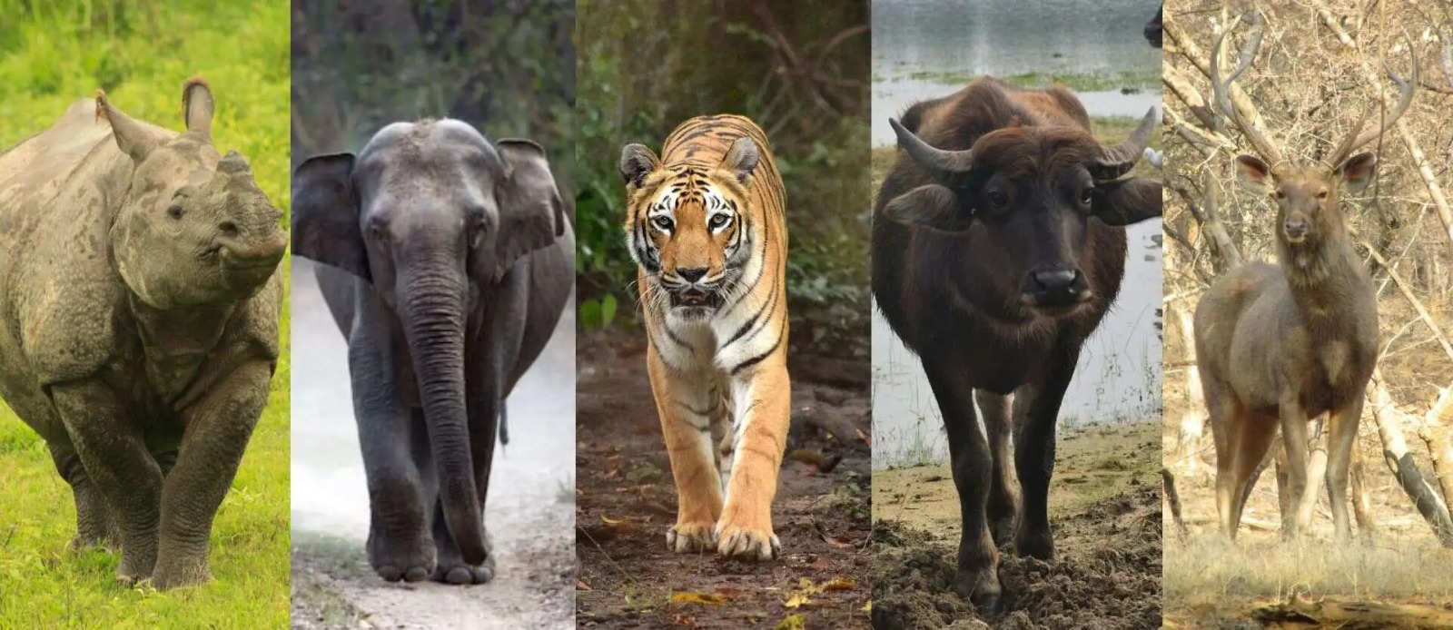 Animals living in Kaziranga National Park
The proposed 34.5-kilometre elevated corridor will allow wildlife from Kaziranga to move freely beneath the road, keeping the landscape intact rather than forcing animals to use limited underpasses. It will be among the longest continuous wildlife-friendly elevated roadways in the world, designed specifically for a UNESCO World Heritage Site that hosts globally significant populations of the one-horned rhinoceros, elephants and tigers.
The Assam government has approved the widening and improvement of the Kalibor–Numaligarh section of NH-715 into a four-lane corridor, incorporating extensive wildlife-friendly measures across the Kaziranga stretch.
The project will be executed under the Engineering, Procurement and Construction (EPC) mode, covering a total length of 85.675 km at an estimated capital cost of ₹6,957 crore.
It will be among the longest continuous wildlife-friendly elevated roadways in the world, designed specifically for a UNESCO World Heritage Site that hosts significant populations of the one-horned rhinoceros, elephants and tigers
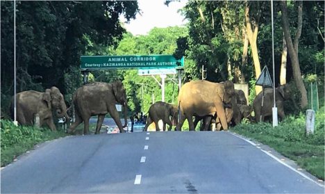
Elephants crossing the road in Kaziranga
The Kalibor–Numaligarh stretch of NH-715 (earlier NH-37) is a vital arterial road connecting Assam's capital city Guwahati with Eastern Assam. At present, it remains largely a two-lane highway, with or without paved shoulders, passing through densely populated towns such as Jakhalabandha in Nagaon district in central Assam and Bokakhat in Golaghat in Eastern Assam.
A significant portion of this highway either passes through Kaziranga National Park or skirts its southern boundary, where restricted right of way, poor road geometry and rising traffic volumes have long posed safety and ecological challenges.
During the annual monsoon floods, large parts of Kaziranga are inundated, triggering mass movement of wildlife towards the Karbi Anglong hills. During this period, the highway turns into a danger zone for migratory animals with many being hit by vehicles and killed despite speed limits and mitigation measures.
The Assam Cabinet has already approved the construction of an approximately 34.5-km elevated corridor through the Kaziranga stretch, ensuring free and uninterrupted movement of wildlife beneath the highway.
Unlike conventional underpasses or culverts, the elevated structure keeps the entire ground below accessible, allowing animals to move naturally along broad fronts rather than funneling them into narrow crossings.
Given Kaziranga’s scale of seasonal movement and diversity of species, officials describe it as a corridor likely to be used by a wide range of wildlife, making it one of the most intensively utilised animal passages in the country.
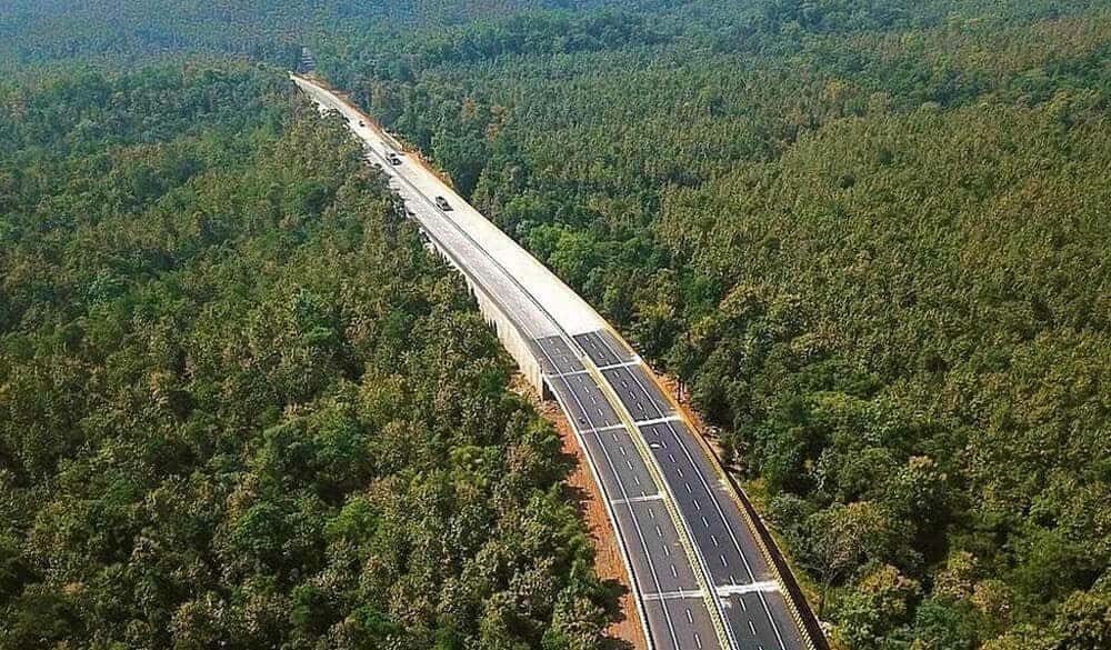
The projected proposed corridor
India already has elevated wildlife corridors in Pench Tiger Reserve across Madhya Pradesh and Maharashtra, while a 20-km elevated corridor adjoining Rajaji Tiger Reserve between Ganeshpur and Dehradun in Uttarakhand is another prominent example.
Conservation planners, however, note that Kaziranga’s corridor stands apart in terms of length, flood-driven animal movement and multi-species use, positioning it as a national benchmark.
The project also includes 30.22 km of at-grade widening of the existing road and 21 km of greenfield bypasses, including Jakhalabandha (11.5 km) and Bokakhat (9.5 km), aimed at decongesting towns and improving road safety.
The upgraded corridor will strengthen direct connectivity between Guwahati, Kaziranga and Numaligarh, linking the state capital, a premier wildlife tourism destination and an important industrial town.
The alignment integrates with NH-127, NH-129 and State Highway-35, and enhances multimodal connectivity by linking three airports — Tezpur, Liabari and Jorhat — and three railway stations at Nagaon, Jakhalabandha and Vishwanath Chariali.
It also improves access to fishing clusters in Tezpur and Nagaon, tribal districts such as Karbi Anglong, and major tourism and religious destinations, including Deopahar, Kakochang Waterfall, Baba Than and the Maha Mrityunjay Temple.
The government estimates the project would eventually generate about 15.42 lakh person-days directly and 19.19 lakh person-days indirectly.
By embedding a long elevated wildlife corridor within a major highway project cutting through a World Heritage Site, the NH-715 upgrade has become a test case for wildlife-sensitive infrastructure in India.
As the country rapidly expands its road network through biodiversity-rich landscapes, the success of Kaziranga’s model could shape how future highways are planned across elephant, tiger and multi-species corridors nationwide.
ALSO READ: First documentary on Kayamkhanis will make you feel proud of this Rajashthan community
After PM Modi lays the foundation stone, the Kaziranga elevated corridor will shift from policy approval to on-ground execution. This moment will be closely watched by conservationists, planners and infrastructure agencies across India and the world.
The writer is an independent journalist who specialises in wildlife reporting


_(1)_(1).webp "Jagannath Rath Yatra")


.webp "BSP Supremo Mayawati")

.webp)